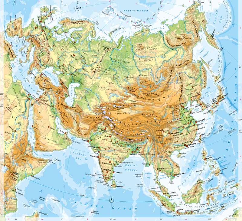
Eurasia - Physical map
Topographic orientation
978-3-14-100890-6 | Page 116 | Ill. 2
Overview
The high mountain ranges of Central Asia and the exposure to the coasts cause an intensive influence of the landscape zonal structure and contribute to the formation of very contrasting Asian landscape areas. In addition to the broad belt of high, geologically young mountain ranges, extensive dry areas and highlands in the interior of the continent, the archipelagos and long island arcs in the East and the subcontinent of India stand out.
Europe, West and South Asia
The Ural Mountains and the Ural River are considered the most important natural borders between Asia and Europe. Between the Caspian Sea and the Black Sea, it is the Kuma–Manych Depression north of the Caucasus.
moreNorth Asia
North Asia extends from the coasts of the Arctic Ocean to the Kazakh Sill and the peripheral mountains of the highlands and basins of Central Asia (Altai, Sayan, Jablonovy Mountains) in the south. In a west-east direction, it stretches from the Urals in the west to the Pacific Ocean in the east. It is divided into three parts in terms of its surface shape and formation: In addition to the West Siberian Plain between the Urals and the Yenisei, which date back to the Palaeozoic era, there is the Central Siberian Plateau between the Yenisei and the Lena (low mountains, Angara Shield), which are also geologically ancient, and the mountains east of the Lena, including Kamchatka and Sichote-Alin, some of which have active tectonics. The islands in the Arctic Ocean as well as the uplifted coastal plains, which only rarely reach larger extents, form their own spatial units. Tundras and boreal coniferous forests, and in Western Siberia also extensive swamps, characterise the landscape over a large area, which, with the exception of the south-east, is very sparsely populated and is only accessible to traffic along a few routes.
South-East Asia
Southeast Asia consists of numerous, mostly mountainous islands, the Malacca Peninsula and a mainland tip in the north that is essentially occupied by Thailand, Laos, Cambodia, and Vietnam. There are clear boundaries to East, Central and South Asia due to mountain barriers and the climatic boundary between the tropics and subtropics.
moreEast Asia
East Asia is defined by the contrast between the mountains, highlands (Tibet) and desert-like basins (Gobi, Tarim, Qaidam, Dsungarei) of Central Asia on the one hand and the fertile, densely populated Great Plains on the other. The river deltas of the major rivers, especially on the Mekong, are also comparable to the Great Plains. Within the mountain ranges, the densely populated Red Basin occupies a special position.
moreSouth-East Asia
Southeast Asia consists of numerous, mostly mountainous islands, the Malacca Peninsula and a mainland tip in the north that is essentially occupied by Thailand, Laos, Cambodia, and Vietnam. There are clear boundaries to East, Central and South Asia due to mountain barriers and the climatic boundary between the tropics and subtropics.
more